

Ash Parish News has created an updated map for 2023 to show the Ash Ranges Technical Area Access. The current public access has been attributed to campaigning from the local community and councilors who strongly opposed the closure of the Ash Ranges Technical Area. Whilst both phases are now completed, many residents continue to call for the full reopening of the Technical Area to its pre-closure configuration. When the flags are down, the highlighted routes are opened to the public. When the flags are raised, new pathways remain open outside of the Technical Area. Ash Parish News reviews the Ash Ranges Technical Area Access in 2023.
What is the public access through the Technical Area?
In a letter to Michael Gove MP, Jeremy Quin MP (the then Minister of State for Defence Procurement) described two phases to re-open access to parts of the Technical Area. Phase One addresses the North/South access via a continuous hardened route. Phase Two provides an East to West route, which now connects Ash Vale to the wider RDA. This access is permitted when the flags are not flying, however, the enhanced perimeter path remains open regardless of the flags.
Ash Parish News has created the following map to illustrate the access with a description of the works completed by the MoD.
Ash Ranges Technical Area Access map 2023
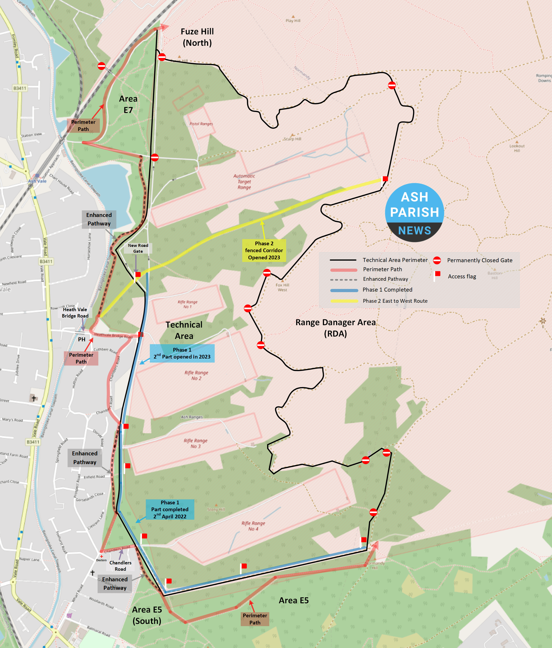
Enhanced Perimeter Path

After the complete closure of the Technical Area in April 2020, the MoD reviewed the outside perimeter pathways. Residents complained that these routes were uneven and muddy, a poor substitute for the hard standing previously enjoyed within the RDA. The MoD connected existing areas of hard standing via a new compacted surface and created and repaired footbridges. The aim was to formalise/create a continuous path around the Technical Area, from which to gain access to the RDA, which remained open throughout. This perimeter path is open at all times, regardless of the flags/activity within Ash Ranges, and is well-used by the public.
Phase One North to South
Phase One was delivered in two stages, the access now connects Fuze Hill North to E5 South. This access connects both the Perimeter Path and the East to West path. To facilitate this access the MoD has now erected new fences to mitigate access to the firing ranges, which is prohibited and dangerous. In particular, it allows those who are less able to access the open space via a continuous section of hard standing.


Phase Two East to West
The purpose of the Phase Two route is to permit residents rapid access to the RDA. The route connects the western Area E7 to the RDA in the East. This generally follows the shortest route following the contours of the land. This route is unpaved but remains popular as it mitigates a diversion of over a mile in either direction. As the MoD required additional fencing and as a consequence of Ash Ranges being a Site of Special Scientific Interest (SSSI) within a Special Protection Area (SPA), a Habitats Regulation Assessment was required prior to any construction works. The letter from the MoD to Michael Gove MP committed to completing this initial assessment by Summer 2022, which did take place. New gates and fencing have since been installed to manage the access through the Technical Area, however, it is reported that this project was delayed due to the impact of the War in Ukraine.


Impact of the War in Ukraine

The MoDs phased access plan within the Technical Area had a number of dependencies, which resulted in project delays. As contractors require access to inspect the routes for the unexploded ordinance, buried services & communication lines, the project had many complexities. These activities could only be carried out whilst the ranges were not in use for military exercises, regardless of whether live firing is in operation. However, due to the onset of the War in Ukraine, the use of Ash Ranges by the UK and Allied military personnel has increased considerably. This means there is less available time to undertake maintenance and projects.
Who held the MoD to account?

When access to the ranges was closed during 2023 the MoD declined to engage both residents and local councillors. This is in line with the UK Government guidance relating to the MoD Contact with the media and communication in public. Representing Ash Parish Council (APC), the previous Chairman of APC, Cllr Nigel Manning, successfully lobbied the local MP, Michael Gove, who in turn lobbied the Minister of State for Defence Procurement. After this intervention, the MoD began a dialogue with APC and became more engaged. This led to the phased return of some access to the Technical Area.
So what is the current access to Ash Ranges?
The majority of Ash Ranges, referred to as the Range Danger Area (RDA) have remained open since the closure in 2020. However, the most frequented portions of what is referred to as the Technical Area(s) have only now partially reopened. When the flags are not flying, the designated routes are accessible. Considering the MoD investment in fencing the likely hood of a full restoration to the pre 2020 levels may seem unlikely, however, the community and local council have continued to challenge the MoD.
What happens when the flags are raised?
When red flags are flying the Technical Area is closed to the public. During this time live military training is taking place, and access is strictly prohibited. The new paths laid outside of the Technical Areas remain open.
When the flags are down, members of the public are advised to stick to the set paths and must not enter the Rifle Ranges under any circumstances.
This system has remained unchanged and is common on MoD training sites.
The map illustrated by Ash Parish News has been created thanks to OpenStreetMap. OpenStreetMap’s data is available under the Open Database Licence. The cartography is licensed as CC BY-SA. To find out more please visit this copyright page.